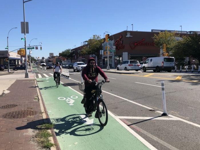
The protected bicycle lane on Northern Boulevard that was completed in October (Photo: DOT)
Dec. 3, 2021 By Max Parrot
Mayor Bill de Blasio and Department of Transportation Commissioner Hank Gutman released a draft proposal for a “streets master plan” Wednesday that is aimed at guiding bus, bicycle and pedestrian infrastructure over the next five years.
The 96-page plan, a product of a 2019 law sponsored by Council Speaker Corey Johnson, gives New York City residents a sneak preview into the locations—including those in Queens—where they can expect infrastructure projects to appear in the near future.
In addition to ushering in sweeping goals like reducing the city’s reliance on fossil fuels and making transportation infrastructure more equitable, the master plan requires the DOT to set ambitious targets for Mayor-elect Eric Adams as he takes over the office.
By the end of 2026, the Council law commits to 150 miles of additional dedicated bus lanes, 250 miles of protected bike lanes within five years, signal priority for public transit at 4,750 intersections and thousands of other upgrades for bus stops.
To accomplish these goals, the Streets Plan outlines a number of locations—including in Queens– where the DOT is likely to focus on over the next five years. The plan included a series of maps.
The plan breaks down its programmatic recommendations into categories grouped by mode of transportation or the different areas of the DOT’s work. For several of these categories—such as traffic safety, walking, transit, cycling and freight– the DOT lists a number of different streets and intersections across the five boroughs where it’s considering projects.
In many cases, however, the report does not always specify what type of project the DOT is considering at a given intersection– and just provides a location.
To add to the uncertainty, Commissioner Gutman points out in his opening message that these lists are merely a starting point for the work under the Adams administration.
“These are proposals, not final determinations, and we expect them to change as our planning work and the community outreach process progresses,” Gutman wrote.
The report also points out some of the ways in which the DOT, in its current incarnation, lacks the capability to meet the benchmarks that the Council law set.
Though the council law sets an average of 30 miles of protected bus lanes per year as a benchmark, the DOT says it’s only equipped to produce 20—at least in 2022; for the 50 mile per year bike lane benchmark, it says it’s only capable to do 30.
The DOT says that meeting these benchmarks will require increased staffing and funding as well as facility space and new strategies.
The plan also creates a standard with the goal of ensuring projects are being put forward equitably so that low-income and racially diverse neighborhoods are not overlooked in street safety improvements. These high-priority neighborhoods are also outlined in the recommendations.
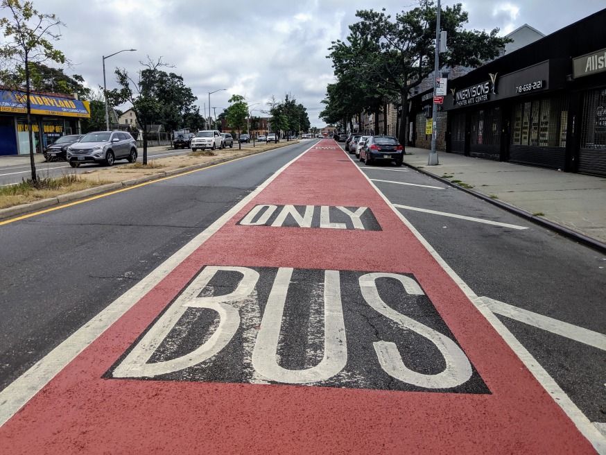
Bus lane along Merrick Boulevard in Southeast Queens (DOT)
Traffic Safety:
The DOT focused on locations where students, seniors, cyclists, and pedestrians have been killed or injured.
In addition to the agency’s standard toolbox of street calming measures like pedestrian islands and sidewalk extensions, the report recommends pursuing bike lane enforcement cameras (to ensure the lanes aren’t blocked by vehicles) and varying the price of parking based on vehicle size, which will both require state legislation to bring about.
Proposed intersections and streets of focus include:
- Wyckoff Avenue in Ridgewood
- 149th Street in Flushing
- Rockaway Boulevard in South Ozone Park
- Queens Boulevard, Skillman Avenue and Roosevelt Avenue in Sunnyside
- Seagirt Boulevard in the Rockaways
- 69th Place, Juniper Valley Road, 69th Street Springfield Boulevard
- Hillside Avenue in Hollis Hills
- Northern Boulevard in Corona
- Jamaica Avenue in Queens Village
Transit:
The DOT has identified potential transit corridors for bus lanes across the city. It also recommended more bus stop amenities and accessibility measures.
In Queens, the report proposes busways on:
- 21st Street in Astoria and Long Island City
- Queens Boulevard in Elmhurst
- Woodhaven Boulevard in Woodhaven
- Rockaway Beach Boulevard in Edgemere
- Northern Boulevard in Jackson Heights
Cycling
The report recommends the DOT develop greenways that are physically separated from vehicular traffic. In Queens the greenways were chosen in part based on the DOT’s 2017 “Safer Cycling” report, which identified three priority districts, with comparatively high numbers of cyclists killed or seriously injured.
These three areas stretch from Corona to Jackson Heights and down to Maspeth, Elmhurst, Middle Village and Ridgewood. The plan identifies area bike Flushing and South Queens as lacking equitable bike infrastructure, but does not propose any greenways in those area.
The proposed bike lane projects cover:
- Utopia Parkway in Bayside
- Ditmars Boulevard in Astoria Heights
- Rust Street, 56th Street, Review Ave. in Maspeth
- Seagirt Boulevard in the Rockaways
- 62nd Drive, 63rd Road to Grand Central Parkway in Rego Park
- The northern section of the Addabbo Bridge and Cross Bay Boulevard
- A bike lane traversing Astoria from East to West
- 31st Street in Astoria
Public Space:
DOT will prioritize the creation of new public space through supporting existing Open Streets and Open Restaurants sites. The plan also calls for creating more pedestrian plazas.
The areas of focus include:
Brookville Blvd., Edgewood Ave. in Rosedale
29th Street in Astoria
Vernon Boulevard Plaza in Long Island City
31st Ave. in Astoria
Thomson Ave. in Sunnyside
46th Ave. Plaza in Long Island City
12th Street Plaza in Astoria
34th Ave. in Jackson Heights
80th Street in Jackson Heights
Hunter Street in Long Island City
Freight:
The DOT will look at ways to reduce trucking, seeking more environmentally-friendly methods to transport freight. This involves using the city’s waterways as well as rail, and will be an extension of Freight NYC, an initiative that New York City’s Economic Development Corporation created in 2018 that proposed investing up to $100 million in freight rail and waterway infrastructure.
The DOT will review the following areas:
Maspeth Ave. And Rust Street in Maspeth
Hempstead Ave., Jamaica Ave. to 225th Street in Queens Village
Hillside Ave. In Hollis Hills
Cody Ave. in Ridgewood
